• Home
  • Outdoor
    • Summit
      • Stories
      • Mountain Log
    • Chasing Waterfalls
  • Social
  • Collection
  • About
  • Contact Me

Kseizetheday

The world as I see it.

November 30, 2015

A friend of mine asked me if I'm interested to join their climb but they're still not sure which mountain to go. Since the said date was a holiday, I answered yes right away. I suggested doing a trilogy (three mountains in a day) hike of Mts. Pamitinan, Binicayan, and Hapunang Banoi just to test my limit since I'm not sure if I'm capable of doing a five mountains in a day hike (Pentalogy) which was starting to get popular during those days. These three mountains are located in Brgy. Wawa, Rodriguez, Rizal. It's a good thing my friend's company agreed as well and we decided to push through the hike. However, only three of us pushed through plan, thus the beginning of Team RAK's adventures.

Mt. Binicayan

I'm sure if you're familiar with this mountain, you would point out my typographical error. Mt. Binicayan, or popularly known as Mt. Binacayan, is our first stop for this trilogy hike. Our guide specifically pointed out that the real name of the mountain is "Bini" and not "Bina".

The first leg of our hike going to our first summit is a concrete road within the community of Brgy. Wawa. After which, we started the trail with boulders and scenic views of the neighboring mountains. We didn't witness the sea of clouds/fogs which engulfs the entire stretch of neighboring mountains surrounding Mt. Binicayan that morning. Instead, we've got scenic views of the Sierra mountain range.


The trail to the summit is characterized by boulders and sharp lime rocks, so it is highly recommended for hikers to use gloves to avoid cuts and bruises.

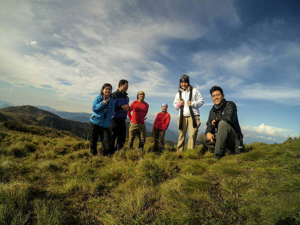
Up in the summit, there were already few groups who were having their photo ops. We joined them by finding some spot for us to have ours as well. From the summit of Mt. Binicayan, the summit of Mt. Pamitinan and Mt. Hapunang Banoi can be seen, as well as Mts. Sipit Ulang, Ayaas, and Balagbag.


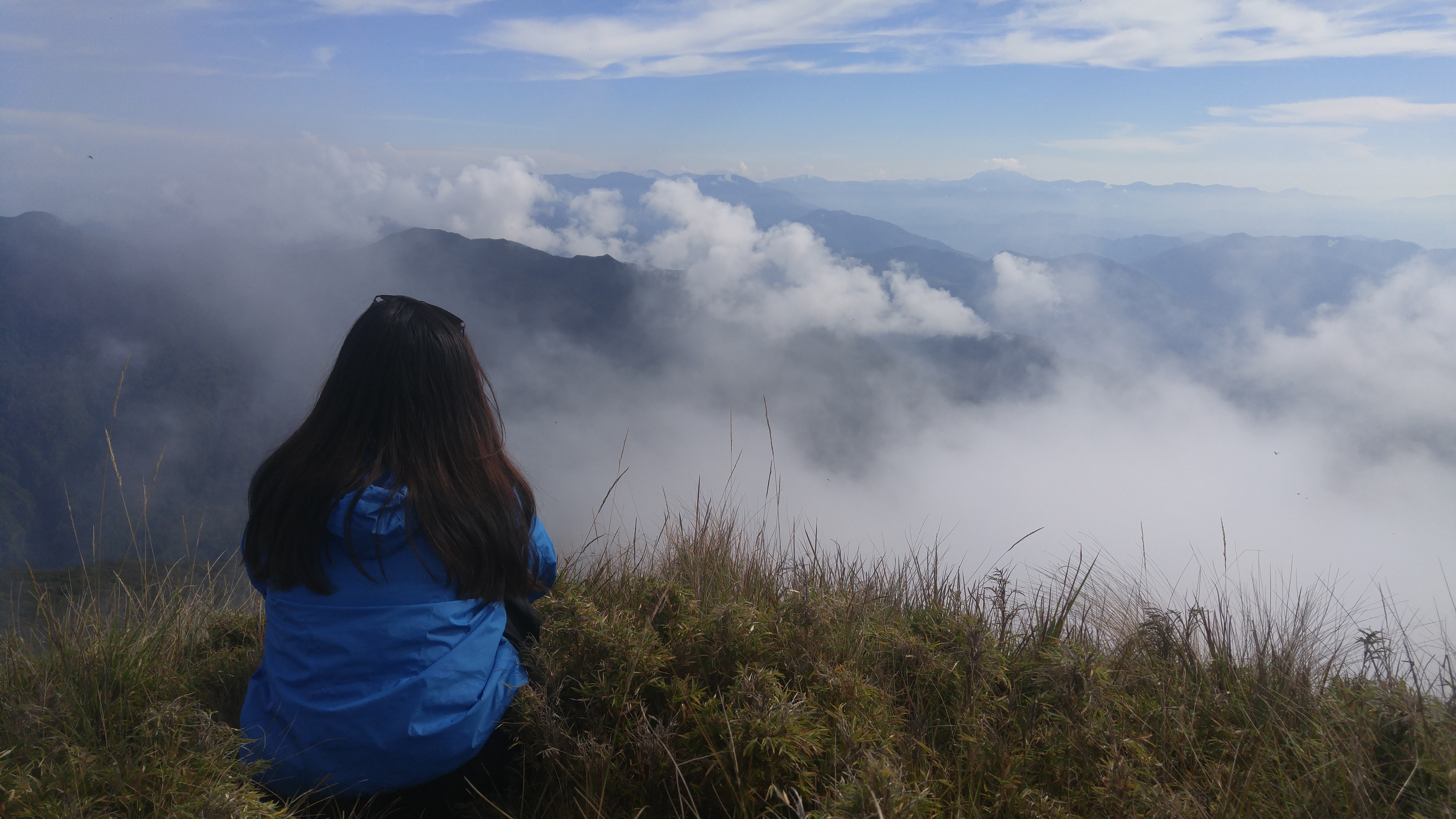
At the summit of Mt. Binicayan. Behind me are Mts. Pamitinan and Hapunang Banoi (left) and the rest of the beautiful Sierra Madre mountain range.
After our short rest and photo ops, we went down and head to our next summit - Mt. Hapunang Banoi.

Mt. Hapunang Banoi

Trail towards the junction of Mt. Pamitinan and Mt. Hapunang Banoi.
We made it at the junction around 10:45 AM and from there we've had our early lunch. It's my first time hiking in these mountains so I cannot compare it as how it was before. Rex, however, have been able to climb these mountains even before it became a hype to mountaineers and tourist, and he said that a year clearly changes a lot in these mountains (check out his entry here).
 
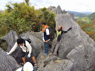
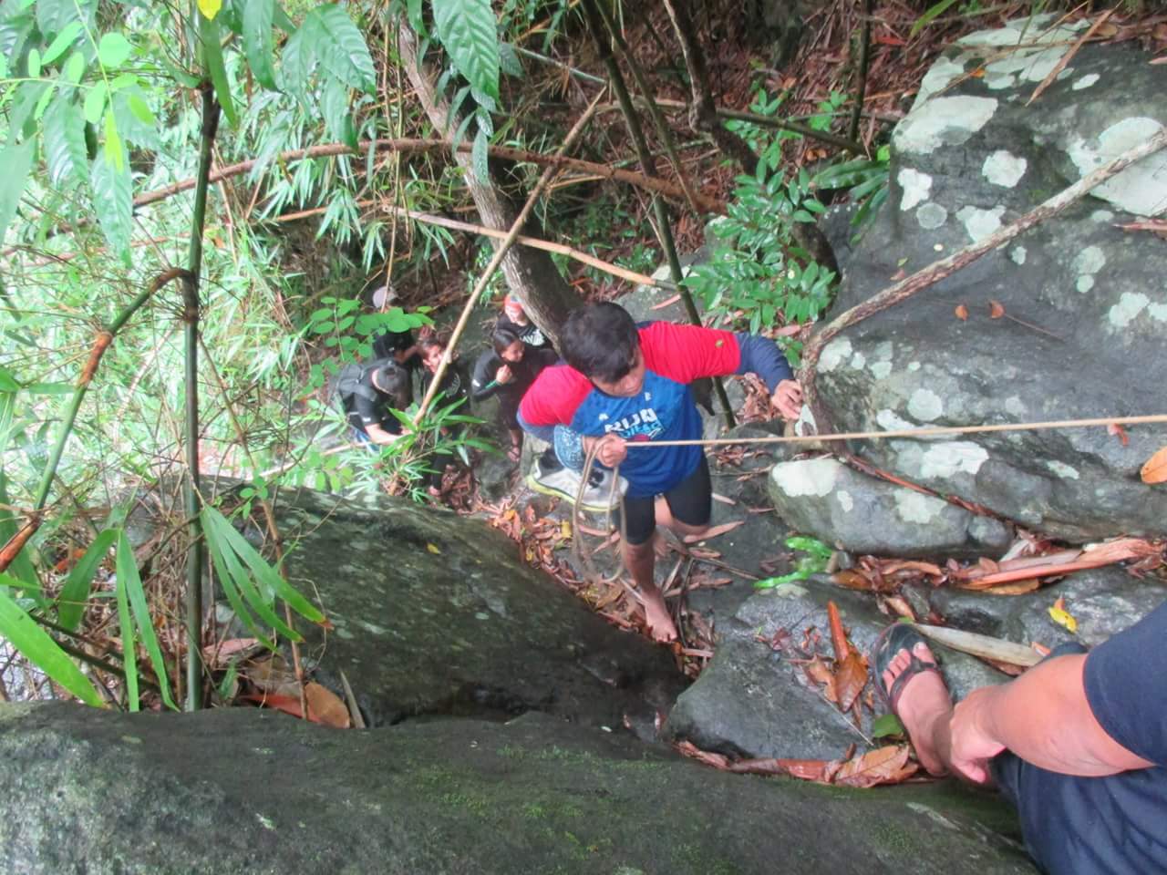
There were lot of hikers who climbed Mt. Pamitinan that day, so we opt going to Mt. Hapunang Banoi first. Like Mt. Binicayan, the trail en route to the summit is composed of boulders and sharp lime rock formations. It is also longer and more challenging. When one of us suffered from leg cramps, we decided to take a rest first a Kemalugong tree nearby. And who would stop us from getting nice photos from there?


Up in the summit are stunning rock formations perfect for your next buwis-buhay pose. But kidding aside, these rock formations sure are stunner.


Done with summit number two! One summit to go! I'm so excited!

Mt. Pamitinan

We reached the junction at around 3:45 PM and after a short rest, we resumed with our hike. Rex advanced quite farther from us since he already knew the trail. Kuya Fernan, our guide, was just ahead from the two of us at the back. I am really excited reaching the third summit, finally my very first trilogy hike! However, as I look back, I noticed that I'm quite far from Arjov. Worrying because he suffered from cramps a while ago, I decided to descend back. From there, my hunch was right and he's having cramps on both legs. I cannot leave a comrade behind, so I told Kuya Fernan to go ahead with Rex while I decided to assist in going back to the junction.

Back at the junction, we were lucky enough to be given free Buko juice by one of the vendors. I've had like 4 cups for free! We waited for our other friend to go back and when he did, we just let him rest for a while.

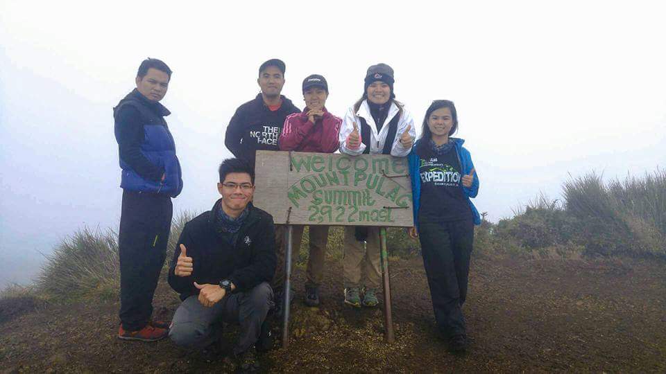
Team RAK. Team Trilogy (accurately, 2.5 for me and Arjov lol)
Unfortunately, just when we're about to start descending, an emergency call catch everyone's attention. One of the female hiker in other group have had her right leg injured and so our guide rushed over the location of the accident. Good thing guides in Brgy. Wawa have 2-way radio that would make communication for emergency like these easier to manage. I salute them for having a reliable and responsive emergency team.
So I guess, it's Montalban 2.5 then.

At Mt. Pamitinan's summit.

Hiking Note

1. Guide fee: Php500.00 (1:5 guide to hiker ratio)
2. Entrance fee: Php20.00
3. Trekking fee: Php50.00

* Be alert to fellow hikers who might have problems. Never let one person lag behind alone.

Going there:
1. Along Aurora Blvd. in Cubao, ride UV express bound to Rodriguez, Rizal (Php50.00/pax)
2. Alight at Eastwood then take tricycle to Brgy. Wawa (Php60.00/trip)

Going back:
1. Tricycle from Brgy. Wawa to Eastwood (Php60.00/trip)
2. UV Express via Litex bound to Cubao (Php50.00/pax)


"You never climb the same mountain twice, not even in memory." — Lito Tejada-Flores

May 28 - 29, 2016

Dry season is about to end, and here comes the rainy months. To cap off our summer adventures, we chose to climb Mt. Pulag via Akiki - Ambangeg trail.

I am all fired up. Two weeks before the actual climb, I already started sorting my stuff to bring - even on the day before our departure! It took me quite some time finishing because I am undecided whether I will be needing some of the stuff on my list, and because it will be my first time to use a rucksack without internal frames. Using a frameless backpack do lighten my pack and it has more room for my belongings, but I really need to pay close attention on how I will arrange my gears so that carrying it would be much better. The same logic goes for internally-framed backpacks, but the things is: in going frameless, your stuff will serves as the form or frame of the pack itself. Note: It is my personal quest to go ultralight - for my beloved spine and knee joints.

Mt. Pulag, the Playground of the Gods.


It will be my second time hiking in the 3rd highest mountain in the Philippines. This time I will be venturing on the challenging trail of Akiki, dubbed as "The Killer Trail", going to the summit and down to Ambangeg trail going to Babadac Ranger Station.

The Killer Trail


Just my two cents, I think this was dubbed as the "killer" trail because the entire trek felt like my gastrocs were about to give up anytime soon due to the steepness of its slopes. Moreover, its terrain and landscape were to die for! It's as if enjoying every moment in this wonderful trail would be my last (definitely not, because I will definitely come back).

gastrocs - colloquial; short for gastrocnemius muscle or the leg muscle.

Of Bridges and Conquering Fears

Note: All photos were captured using LG.

Bridges - no matter how scary it is - CONNECTS.

We had our breakfast at Jang-Jang Eatery. Behind it is where the longest hanging bridge in Kabayan, Benguet can be found. It was actually my second time crossing it. I still feel afraid and giddy at the same time.

Of all the bridges I've crossed so far, nothing beats my fear of crossing the one located at the Eddet River. My hands were literally shaking that I didn't get a decent picture while crossing it. I made it though. Happy kiddo!

Rich flora and fauna

From the Mt. Pulag Visitor Center (DENR), to the glorious mountain itself - a vast biodiversity can be found.

(above) Caterpillar seen at DENR Visitor Center.


(above) found along the trail and at the summit.
Among the documented plant species found in the mountain is the endemic dwarf bamboo (Yushania niitakayamensis) and the Benguet pine (Pinus insularis).

Unfortunately, we did not have the opportunity to catch sight of several animals such as Philippine deer, giant bushy-tailed cloud rat “bowet,” long-haired fruit bat, the 185 grams dwarf cloud rat (found in 1896), and the Koch pitta bird during our trek.

The Experience

Brave souls

From the jump off point to Eddet River, the trek was easy to moderate, with some rolling terrain and rocky areas. For a three days itinerary via Akiki trail, setting camp near Eddet River is ideal for Day 1. For our group with a 2-day itinerary though, we passed by the river and continued on to our journey up to Marlboro Camp.

Eddet River 

Akiki trail was indeed difficult. From Eddet River all the way to the grassland slopes, the trail seems like an unforgiving assault. Good thing it was a switchback trail, one that is in  zig-zag pattern instead of a straight trail upward a steep slope. Moreover, the pine forest and fireflies roaming at night makes the difficult experience worthwhile. I do hope my camera could capture the fireflies, but I guess some of the best moments in our life were left uncaptured.

We're burning fires, 'til our lives are burning gold.
Mt. Pulag is also a sacred mountain and a burial ground for some indigenous people of Benguet.

This burial site is closed for tourist or mountaineers but can be seen along the trail.


Unexpected Blessings

It was a rainy evening when we made it to Marlboro Camp. I actually lose hope in having good weather ahead of us. But boy! how glad am I to see a clear sky that early 2 in the morning! We even get a chance to capture the Milky Way.

Milky Way
The Galactic Core - perfectly spotted just in front of our camp.
We started roughly around 4am on our trek from Marlboro Camp entering mossy forest all the way to the grassland slopes, and finally reaching the Saddle camp before having the final leg of our assault to the summit. It was indeed late and so most of us were not really expecting to witness the famous sea of clouds. Some even stopped and just take their time trekking, but we continued on. We may be rushing our way to the summit, but it is our goal anyway and so we continued moving forward. Glad that we were granted a beautiful display of clouds at the summit before it became covered with fog.

PuLOVE is sweeter the second time around.

FB_IMG_1468249749008
Team 1 at the summit.
FB_IMG_1468249801924
Team 1
  • I really admire the couple wearing red. I don't know if it is selfishness to wish for someone whom I could travel with - not for a season, not for a year, but as long as our joints permits hiking mountains, swimming in the deep blue sea, or just simply being with each other for a lifetime. Maybe it is selfishness or maybe because I'm reading Norwegian Wood lately.
Going down, I can say that I am so proud of myself! For I can still remember the path we take going back to Ambangeg trail of Mt. Pulag way back 2014.

IMG_20160602_201605[1]Upon entering the short, yet thick mossy forest of Ambangeg trail's Camp 2, I was surprised to see the positive changes it undergoes from how I remember it two years ago. This is one of the things to be proud of for the local governing bodies regulating the conservation of one of the country's Natural Park. If I am not mistaken, a year or so, camping was prohibited in Ambangeg trail's Camp 1 and 2 of Mt. Pulag to keep the vegetation from being destroyed by irresponsible campers. I think they have made the right decision. A positive outcome indeed.
It was a fleeting moment for me to find that my hiking skills did improve from the very first time I started hiking - the activity itself and Mt. Pulag.
I'll keep revisiting this mountain, hopefully in other trails like the Ambaguio and Tawangan too. Someday, who knows. I hope I'll be much stronger then.
Now here's a cup of coffee to celebrate our successful climb in Mt. Pulag via Akiki - Ambangeg trail which took us 9 hours in total to finish.

IMG_20160604_220817[1]
Cheers!

Take-aways
These are the lessons and suggestions I learned through our climb:
  • Mt. Pulag via Akiki trail is considered a major hike. I guess one of the shortcomings of the event was that no pre-climb meeting was done. We were not familiar with all the joiners in the event. We do not know who have had it as their first time doing a major hike, who does this and that to prepare as there were some delay in our itinerary. Good thing we found company who have the same goal and pace as ours. We were not the strongest but sharing the same spirit keeps the mood on the brighter side.
  • Medical Certificate are required in getting permission to climb Mt. Pulag so it is advisable to get it ahead of time so as not to delay the itinerary. Just a simple courtesy to those who do so prior to the day of the climb.
  • The best time to climb Mt. Pulag starts with November to March.
  • There are lot of event organizers in facebook who have scheduled climb in Mt. Pulag. Be extra wary of the inclusions and price you are paying. If it's worth it, go for it. Try to compare each packages as well.
For the itinerary of our climb, you may want to check Carving That Niche
"Kidlat" - September 2015


How to Get There:

From Cubao to Alas Asin (vice versa)
Ride a Mariveles-bound bus

At Five Star bus terminal, look for Bataan Transit Co., Inc. bus:
First trip: 12MN
Last trip: 9:30PM
Fare: Php267.00
  • There’s a sign along the road of Brgy. Alas Asin showing the way to Tarak Ridge.

Actual itinerary:

Day 0:
2300H Meet up at Five Star, Cubao.
0000H Departure from Cubao to Alas Asin via Bataan Transit bound to Mariveles.

Day 1:
0300H Arrival at Brgy. Alas Asin, registration at the Barangay Hall (Php10.00)
0330H Start trek from the road sign.
0430H Nanay Cording’s house, continue trekking
0700H Papaya River
0800H Continue trekking
0930H Grassland towards the ridge
1040H Peak of Tarak Ridge, the Lonesome tree (aka Kidlat)
1100H Lunch
1200H Start descent
1400H Papaya River, swimming and photo-ops
1500H Start descent
1650H Nanay Cording’s house
1800H Arrival at the Barangay Hall, tidy up.
  •  Since the last trip of bus passing through Brgy. Alas Asin bound to Cubao was at six (6) in the afternoon, we rode a mini bus bound to Balanga instead. We did not reach the Balanga terminal, as we already spotted a bus going to Cubao and rode from there.
  • We were back to Cubao at around 2200H.
Other:
We were into moderate to fast pace, but have had long rest at Papaya River to and fro the ridge. One can opt to day hiked at Tarak Ridge, with short stop at Papaya River to save time, and have a sidetrip at Sisiman Bay, where trekking to San Miguel peak is also possible for around 20 to 30 minutes.

The difficulty of the trail is not for novice hikers, but if you want to challenge yourself, why not? I still believe in the power of determination and strong will.

Pinoy Mountaineer gave this a difficulty of 4/9.


Aside from the beauty of the landscape one can see in the mountains, I always get excited seeing new things on the trail. I see beauty even on small things, perhaps because it is more often neglected by the eyes.

A caterpillar with long spikes spotted clinging on to this flower at Mt. Pulag DENR office.
 It is like a whole different world and recording an image that is not easily seen by the naked eye is a very attractive opportunity. It is not an easy task taking photos of these "tiny" objects. Sometimes I come across a very pretty violet dragonfly, and as much as I want to get as close as possible to this beautiful creature, I can't because it would fly away with just small movement.

This moth is pretty friendly. I did not fly as soon as I get close to it.
Getting close to idle insects, plants or objects and I could get a pretty rewarding result because I could put more emphasis on the details, pattern, and texture of the object that I would like to capture.

Morning dews in a flower. Taken at Mt. Pulag grassland.

In this light, I find the Huawei P9 a very promising phone which took smartphone photography to the next level. The dual-lens camera is co-engineered with Leica - one of the world's premium camera lens - capturing brilliant photos, sharp images, and with depth measurement ISP for improved image focusing, speeds, and processing.

Let's explore a world of infinities.


It has a "Hybrid Focus" technology for taking photos of superb speed, depth, and clarity. All this features packed in a sleek, elegant, premium, and stunning design - you can take it it anywhere and never miss a moment.

Change the Way You See Beauty through Huawei P9

September 6, 2015

The prelude to the new chapter of my life.

Tarak Ridge (1,130+ MASL), found at the west side of Mt. Mariveles, is a popular hiking destination in Bataan. It is located in Mariveles with its jump-off point at Brgy. Alas Asin.

Highlights

  • I joined a group of total strangers.I don't know where I get the guts to do it, but I have no regrets at all. I made new friends!

New hiking buddies!

  • Dim-trekking. We started our trek as early as 3am. It was really dark along the trail, and I rely only on the flashlight I brought along with me. We did not hire a local guide with us because someone in our group was already familiar with the trail. It had rained the previous night and so the trail was muddy.

Muddy trail

It was a long walk from the jump-off marker, passing through Nanay Cording’s abode, and on to the trail going to Papaya River. It was dark but one can see how thickly forested the trail was. They say monkeys can also be seen along the trail but since it’s dark, I guess the monkeys were still fast asleep to put a show off.

The sun was already up when we reach Papaya River. There were overnight campers near it and we pay a courtesy call to them as well. They were kind enough to offer us some early morning munchies as well. I refused and just enjoy the serene river up ahead wherein we spend an hour or so. The water was clean, clear, and potable. I quench my thirst by drinking water from the river, and save the remaining of my 500ml Gatorade. It was a refreshing drink, really! I was tempted to have a cold dip in the river as well, but we still got a long way ahead of us, and so we moved on.

Papaya River
Clarity
The trail after the river was getting steeper and there were times that I have to scramble all the way up. There were roots that can one can take a hold of.

Steep
Once we reach the grassland, the trail became rocky and the soil, loose. We met other hikers as well. There were no clearing that time, and so we continue on to our hike to the peak of the ridge where a lonesome tree can be found as a marker.

The lonesome tree, aka "Kidlat"
We reached the peak at around ten in the morning – still no clearing. We’ve had early our lunch; some even had taken power naps while waiting for the others. I waited for the clearing, I am still hopeful for even just a glimpse. And I’m glad I waited. Suddenly, the fog disappeared giving us view of the nearby peaks of Mt. Mariveles. We waited for some of our co-hikers but since they’re taking a long time, we decided to go down. We learned afterwards that most of them decided not to go on and stayed at the lower part of the peak. We regrouped and back trailed to Papaya River where we’ve had a cold dip and photo-ops.

Better days are coming.
Pass four in the afternoon, we reached Nanay Cording’s house and had short chat with her while waiting for the others. From there we have the option to hire a tricycle to the Barangay Hall, but we chose to walk instead.
Sir Ghil, Nanay Cording, and Me.

Please do check my documentation of the  Flora and Fauna Collection that I spotted along the trail.

Take-aways
* Be mindful of your surroundings. Focus on the trail.
** Hike at your pace. Going too fast or too slow will make you feel exhausted fast. However, see to it that you would not stray too far from your group.

* as of June 2016, the tree at the peak of the ridge already fell down due to unknown reason. It was such heartbreaking news for me and for those who find this tree memorable. To whatever they called you, you will always have a special place in my heart.

* This hike was made possible by Ulupong Mountaineers, through Mr. Dharz Malonzo and William Pajarillo.


August 1 - 2, 2015 - Bikers at the summit of Mt. Balagbag   
It was that same friend of mine from Mt. Daraitan who, this time, invited me for a hike. She told me that we will be traversing Mt. Balagbag to Mt. Maranat. Traverse? What was that? Is it possible to hike 2 mountains in a day? Because one is enough for me and I get exhausted easily. Anyway, I still give it a go since this time we're going as a team (we also have our drifit shirts with the name of our group in it - Hikayat Mountaineers).

In the end, I learned the meaning of the word "traverse" in a hard way. Well, an unforgettable one.

About the mountains:
Source: Pinoy Mountaineer
Mt. Balagbag offers considerable view of Ortigas and some parts of Metro Manila, as well as the Ipo Watershed. Mt. Oriod and neighboring mountains of the Sierra Madre Mountain Range can also be seen from the summit. It is also popular to mountain bikers because of its open wide trail. Trekking in this mountain can be debilitating during summer because of the scorching heat of the sun, so dimtrekking is advisable.


Maranat Range, also known as Mt. Maranat, is part of the Sierra Madre Mountain Range boasting flamboyant vegetation, rolling terrain, pools, stream, and waterfalls.

Unknown to many, “Maranat” is actually the name of the falls, which belongs to Mt. Oriod. It is so majestic and challenging - with big boulders one can climb by hand or with aid of ropes, trees and fallen logs framing up the views, and cold water that is so refreshing upon every dip. It truly offers such a wonderful experience for outdoor enthusiast.

Highlights
  • Meeting people who loves the outdoor too.
  • The wide, open trail going to Mt. Balagbag's "helipad" summit.
  • Meeting bikers along the trail.
  • Balagbag's kitty cat, most commonly known as Garfield. Really playful and fluffy. I love cats.
  • The Sirko-Balentong trail (Balagbag loop) traversing to Maranat Range and Waterfalls - not a beginner-friendly trail.
  • The homey campsite of Tatay Nestor at the Maranat range.
  • Chuck "the camera-shy dog" and Jerry "the sleepy cat", pets of Tatay Nestor.
  • The trail runners who were really close to Tatay Nestor. Well, it's the first time that I actually encounter the term "trail runners". I am really amazed by how strong these people are! I mean, hiking/trekking on a mountain is definitely hard and they're running on the trail. Whoa!
  • The beautiful, challenging, and magnificent Maranat Falls. For exploration, I highly recommend starting from the foot of the falls all the way up. It's definitely adventure-filled!

Photos

Hikayat Mountaineers
The group was formed June 18, 2015 during their Buntot Palos falls exploration. I wasn't able to join them, but they were kind enough to welcome me in the group.
Where bikers and mountaineers meet - "Helipad" summit
I haven't tried overnight camping at Mt. Balagbag but it could be one of the options. One might be able to see the beauty of the city lights but I think stargazing is not as grand as it is in other Rizal mountains because of the light pollution. I'm not even sure if the Milky Way can be seen in the summit in its time of the year.
Garfield. Let me scream like Agnes, saying "He's so fluffy, I'm gonna die!"
 Mt. Balagbag is popular to bikers as well
Upon traversing to Maranat range, we were unaware that the path we were taking was the Sirko-Balentong (Balagbag loop) trail. There have been misunderstandings with the guide and my co-mountaineers who have been to Mt. Maranat before. Long story short, I will name this trail as the "Paasa" trail. Why? Because there will always come a time where we could see the campsite and the falls, but then we were off to the trail again with tall cogon grass, then bushes and trees. It was literally the "so close, yet I think we're going far from the campsite again" trail. The end of the it includes crossing boulders in the river, walking unto steep and narrow beaten track, and then welcomed by the sight of the falls. It was excruciating, specially for the beginners (it's not my first time but I still consider myself as a novice). Our traverse took around 8 hrs to finish, which is usually around 3 to 4 hrs only.
First leg of the Sirko-Balentong trail
Tired and hungry, we immediately set up our camp. Some of us chose to dimtrekked back to the jump off point since they're only prepared for a dayhike. I set up my hammock at Tatay Nestor's house with the help of one trail runner named Kulot (we call him Kap Kulot, "Kap" stands for kapatid).

Nothing beats waking up in a hammock.
Meet Chuck. He's friendly but a bit camera shy.

This is Jerry. He loves sitting on a Hooman's lap and sleep.


If you want to know where your heart is, look where your mind goes when it wanders.
Mt. Balagbag as seen from Maranat campsite.

Hiking Notes:

Transportation:

  • From Coastal Mall/Gil Puyat (Buendia LRT)/Cubao (EDSA):
    • Ride a bus with route going to Tungko (just look for buses with signage SM Fairview Tungko)
  • From Tungko, go to the jeepney terminal and look for Licao-Licao bound jeepney.
  • From Licao-Licao, it is optional to ride a tricycle going to the jumpof point which is the Brgy. Hall of Sitio Balagbag.
Registration:
  1. Barangay Hall - P10.00
  2. Junction -           P20.00
  3. Guide -  not required; contact Kagawad Toto (+639302355562) or Pitoy (+639193265454) for the latest guide fees.
Sidetrips:
  • Maranat Range/Falls (permits are required as of 2016)
  • Resorts (there are newly established resorts at the local community, haven't tried one yet)

My Take-aways
☑ Climb smart.
☑ Hiking in larger groups has its perks. You'll never get bored with all the fun stuff you share with each other.
☑ Climbing mountain is also a test of patience. Be sure to buy that Pasencia in your local bus terminal.

Older Posts Home

ABOUT THE AUTHOR

Hi! I'm KC!

I love to wanderscape and capture moments. Life is a multicolored spectrum.

Carpe diem!

LATEST POSTS

  • Three Summits in a Day - Montalban Trilogy
  • Revisiting Mt. Pulag National Park
  • An Island of Surprises: Capones Island
  • Mt. Balagbag and Maranat Range
  • Mt. Mariveles: Tarak Ridge Flora and Fauna Collection

Categories

Art Camara Capones Chasing Waterfalls Climb Collection Down the Shore Fauna Feature Flora Hike Hiking Notes Islands Mount Pulag Mountain Nature Outdoor Poem Pundaquit River Sea Sketch Summit Summit Stories Travel Travel Guide Tree Trek Tropical Watercolor Waterfalls Zambales

Popular Posts

  • Three Summits in a Day - Montalban Trilogy
    November 30, 2015 A friend of mine asked me if I'm interested to join their climb but they're still not sure which mountain to go....
  • Revisiting Mt. Pulag National Park
    "You never climb the same mountain twice, not even in memory."   — Lito Tejada-Flores May 28 - 29, 2016 Dry season is abo...
  • An Island of Surprises: Capones Island
    "Every cloud has a silver lining" - English idiom Year-end adventure be like: Plan A: Go with some Rizal-based professio...
  • Mt. Balagbag and Maranat Range
    August 1 - 2, 2015 - Bikers at the summit of Mt. Balagbag       It was that same friend of mine from Mt. Daraitan who, this time, invite...
  • Mt. Mariveles: Tarak Ridge Flora and Fauna Collection
    Flora and Fauna Collection I am not familiar with the common names or scientific names of the following, but I would be really grateful i...
  • Change the Way You See Adventure
    Adventure. Before, I would find adventure in extreme rides found in theme parks. Watching death-defying stunts, dangerous, or extreme spo...
  • Maranat Range/Falls
    The majestic Maranat Falls. August 2, 2015 Part of our Mt. Balagbag - Maranat Range traverse was our sidetrip to Maranat Falls. Mar...
  • Playground of the Gods - Mt. Pulag
    MT. PULAG VIA AMBANGEG TRAIL February 15-16, 2014 About the Playground of the Gods Mount Pulag is the highest peak in Luzon standin...
  • Mt. Mariveles: Tarak Ridge
    September 6, 2015 The prelude to the new chapter of my life. Tarak Ridge (1,130+ MASL) , found at the west side of Mt. Mariveles, ...
  • Mt. Daraitan
    April 30, 2015 Part of our Labor day getaway adventure featuring Mt. Daraitan + Tinipak River and Cave + Batlag Falls + Daranak Falls ...

Blog Archive

© 2016 by The Panchromatic Mix. Powered by Blogger.

Stats

Advertisement

Instagram @kseizetheday

© 2016 Kristina Cuenca: All Rights Reserved. Designed by OddThemes & Distributed by MyBloggerThemes